Wheldrake Ings is subject to flooding and may be inaccessible at various times throughout the year. Follow @LDV_NNR on X (formally Twitter), Facebook or @ldvnnr.bsky.social on Bluesky for the latest updates.

(c) Lucy Murgatroyd
Wheldrake Ings Nature Reserve
Location
OS Map Reference
SE 69413 44416View on What3Words

Know before you go
Dogs
When to visit
Opening times
Open at all timesBest time to visit
March to end June for breeding waders and meadows. November to end January thousands of migrating birds once floodedAbout the reserve
A walk at Wheldrake Ings is a chance to press pause on daily life, breathe and take in the stunning wildlife spectacles that change dramatically across the seasons.
In winter, the River Derwent floods, often turning the valley into a huge lake. The water attracts colossal numbers of ducks, geese, swans, gulls and waders - an incredible sight to behold in its own rights, but also an enjoyable challenge for keen birders looking for something unusual among the masses of birds. It could be a smew, scaup, or even something rarer, like an American wigeon or green-winged teal. Suddenly hundreds of ducks and waders rise noisily up from the water and chaos briefly ensues, as a hunting peregrine or marsh harrier scatters the flock.
Spring is very different. The reserve is alive with the songs of warblers, the meadow is drying out and wildflowers emerge in abundance, bustling with insects. Listen for the call of cuckoos and watch in awe as hobbies dash over the grassland and wetland.
Endless possibilities
There's so much to discover here - the calls of curlews, snipe and skylarks in the spring, a glimpse of an otter or kingfisher along the river, rare plants in the meadow... To see the flowers at their best, join a guided event in summer, as there's no access into the meadow.
Bring binoculars or a telescope to get the best views of the birds on the water from the three hides, and keep an eye out for elusive species like spotted crake and water rail, as well as breeding willow tits. Spring and autumn are best times to check for rare migrants.
Accessibility and facilities
As a floodplain, the site and accessible area is generally flat. There is one linear route which has been surfaced with chippings but can be uneven with pot holes, Grass grows through the track which is cut sporadically.
The site and car park can flood for three to five months of the year resulting in it becoming cut off by flood water, Following flooding, a lot of mud is deposited on the track and reeds, logs and debris on boardwalks making them slippy.
Entrance to the bridge is over the metal bridge across the river Derwent and turn right. The main metal field gate is usually open and locked at night. A metal kissing gate to the side is inaccessible for prams and wheelchairs.
There are two benches along the route and three hides.
- Tower Hide has steps both at the entrance and inside. Benches are provided inside, but no wheelchair viewing space.
- Pool Hide: Door is standard width with a ramp. Moveable benches inside for viewing.
- Swantail Hide: Ramp at appropriate angle and width for wheelchairs but ground leading up to hide is uneven. Space and window height for wheelchairs.
Nearest accessible toilet is at Natural England's Bank Island Office with a radar key. There is an unsurfaced path between the two reserves.
Refreshments are available in nearby Wheldrake village.
Phone coverage is reasonably good throughout the site
Environmental designation
Seasonal highlights
- Spring: Plants - Marsh marigold; Cuckooflower; Birds - Whimbrel; Mammals - Brown Hare
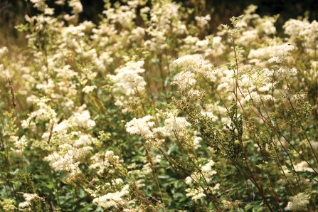
- Summer: Plants - Great burnet; Meadowsweet; Meadow vetchling; Invertebrates - Banded demoiselle
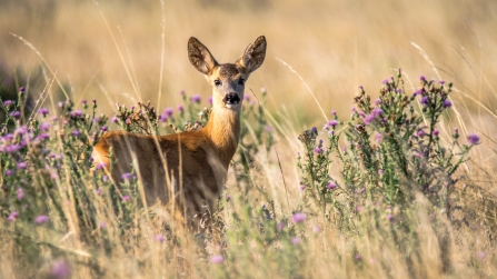
- Autumn: Birds - Barn owl; Willow tit; Mammals - Roe deer
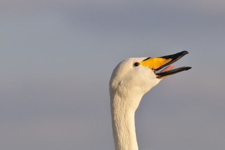
- Winter: Birds - Whooper swan; Wigeon; Teal; Pintail; Peregrine
Directions
Directions
If coming from Wheldrake village, leave village and take sharp right, past Natural England offices and Yorkshire water depot on the left, turn next left by the deer crossing sign down and down Ings Lane to the car park.
Please do not obstruct the ramp onto the bridge as it is the only access route off the reserve.
Public transport
There is a regularly service between Wheldrake village and York Merchantgate (bus 36 to Sutton on Derwent and 18 to Holme Upon Spalding Moor). This service also passes through Skipwith, North Duffield and Bubwith. Please check with the local bus companies (Transdev and East Yorkshire Motor Service) before travelling as bus routes are prone to change.
By car
Eight miles south east of York, four miles east of the A19. From Wheldrake follow the road (Carr Lane) towards Thorganby and out of the village where the road takes a sharp right turn. 0.5 miles further on a narrow road to you left (after the Yorkshire Water compound) takes you down to the nature reserve. Park on the stony area next to the bridge over the River Derwent.

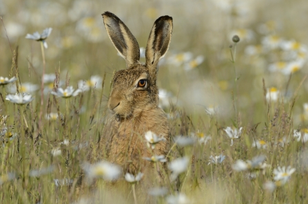
Brown hare © David Tipling/2020VISION

Curlew © Richard Steel/2020VISION
Magical Wildlife Moment
The distinctive call of a curlew in the grassland or flying overhead.

The autumn colours were even more beautiful when the sun came out
Photo Credit - Telling our Story Volunteer, Sara


