
Skerne Wetlands Nature Reserve
Location
Cleaves Farm, Skerne (Skerne Wetlands entrance - southern part of site)
OS Map Reference
TA 0641 5593 (Wansford Bridge)TA 0598 5408 (Skerne)
View on What3Words

Know before you go
Dogs
When to visit
Opening times
Open at all timesBest time to visit
March to JuneAbout the reserve
Skerne Wetlands - made up of Snakeholm Pastures to the north and Skerne Fen and Skerne Reedbeds downstream - is a reserve that's come a long way in a short time. This wetland complex features wet grassland, over a mile pf chalk stream, and more than 70 former fish farm ponds, which have been transformed into a mosaic of wet woodland, reedbed, fen and open water.
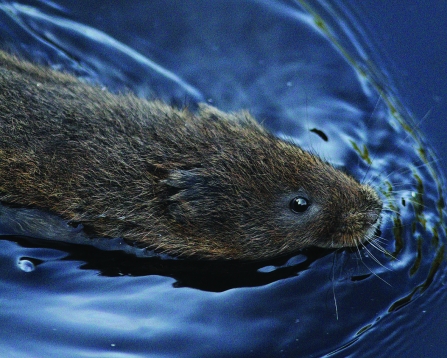
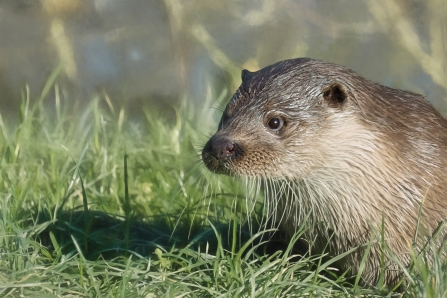
Every visit to this restored wetland paradise is a chance to discover something new and exciting - a marsh harrier floating above the reedbeds, otters along the stream, green sandpipers on the muddy pool fringes, or dragonflies among the tall purple loosestrife.
Waters rich in oxygen and wildlife
Here in the headwaters of the River Hull, the chalk streams at Skerne Wetlands are a nationally-important habitat. West Beck's beautifully clear, oxygen-rich waters, lush bankside vegetation and stunning beds of water crowfoot are unmissable in early summer.
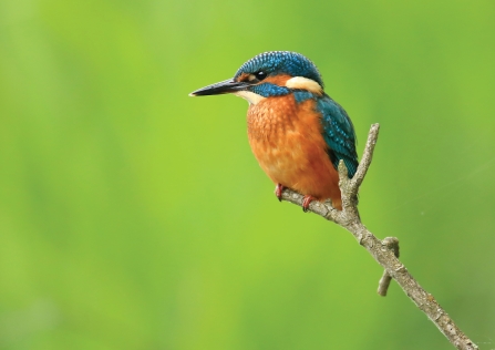
The beck is home to wild brown trout, grayling and brook lamprey, as well as water voles and kingfishers. It's rich in insect life too, including mayflies and caddis flies, which attract wagtails and other insect-eating birds.
Accessibility and facilities
There are several benches and seating spread along the routes. There are two flat bridges – one with a slight slope down to it.
There are three viewing screens all with benches.
The nearest public toilets and amenities are in Driffield town centre – about 20 minute drive away
There is reasonable mobile coverage on the reserve depending on your phone provider.
The What3Words code for the car park is taped.caged.aced ; for the Skerne entrance (south entrance) placidly.skate.quest; for the Snakeholme kissing gate (north entrance) squeaking.sonic.prestige
Seasonal highlights
- Spring: Birds - Yellow wagtail; Fish - Brook lamprey; Invertebrates - Orange-tip; Reptiles - Grass snake
- Summer: Invertebrates - Emperor dragonfly; Fish - Brown trout; Mammals - Water vole
- Autumn: Birds - Green sandpiper; Kingfisher; Invertebrates - Common darter
- Winter: Birds - Bittern; Barn owl; Fieldfare; Redwing; Mammals - Otter; Roe deer
History
The River Hull Headwaters nature reserve was purchased in 2008 as two grass fields – Snakeholm Pastures, adjacent to the Wansford Bridge, some four miles southeast of Driffield, in the heart of East Yorkshire. Then, in 2011 Yorkshire Wildlife Trust bought what at the time was a commercial fish farm covering 33 hectares along with around a mile of the West Beck chalk stream.
This is now known as Skerne Wetlands and in 2014 the Trust completed the purchase of a further 12 hectares of land on the opposite side of the chalk stream to extend the nature reserve to more than 40 hectares and 2.4km (1.5 miles) of chalk stream.
The site complex of more than 80 former fish farm ponds is being developed into a mosaic of wetland habitat to include wet grassland, wet woodland, reedbed and open water. The latest section of the habitat creation, integrating the Copper Hall section of the wetlands into the reserve, completed in early 2018, thanks to a partnership between Yorkshire Wildlife Trust, the Environment Agency, Natural England, East Yorkshire River Trust and Yorkshire Water.
Directions
Public transport
Closest train station is Driffield. Bus to Wansford.
By car
Snakeholme pastures lies just south of Wansford Bridge off the B1249 southeast of Driffield. A small amount of roadside parking exists. Skerne Wetlands is accessed along a farm track just east of Skerne Village. Turn south off the road, left at the fork, right towards Cleaves Farm and follow the track past the farm to the end where parking is available.

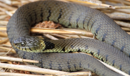
Grass snake © Allen Holmes
Mark Coates

Brown trout © Linda Pitkin/2020VISION
Magic Wildlife Moment
Watching the crystal-clear waters of the chalk stream and spotting a brown trout or water vole.

The autumn colours were even more beautiful when the sun came out
Photo Credit - Telling our Story Volunteer, Sara


