Can we manage both lowland peatland restoration and agriculture on the Humberhead Levels?

Can we manage both lowland peatland restoration and agriculture on the Humberhead Levels?

Snipe © Allen Holmes 2019

Mike Jones, South region projects manager, describes how managing water levels on agricultural land in the Humberhead Levels could have significant benefits to biodiversity and climate change.

Lowland peat is often overlooked in favour of our majestical and wild uplands, made famous in film, literature, and more recently in sitting the benchmark for peatland restoration. But the areas that lie in our traditionally agricultural lowlands, surrounded by major transport hubs and industrial epicentres, have an equally important role to play as we manage and mitigate a changing climate.

For the past year, we have been working alongside Nottinghamshire Wildlife Trust and local landowners on the Humberhead Levels to explore how managing water levels on lowland peat – a historically-overlooked habitat – could make a real difference to local biodiversity and the impacts of climate change. 

As awareness of the importance of landscape-scale restoration projects and the increasing competing demands of nature recovery and agriculture on land grows, this discovery project had the potential to deliver some significant findings for local ecologists and the farming community alike.

Why is lowland peat and the Humberhead Levels important?

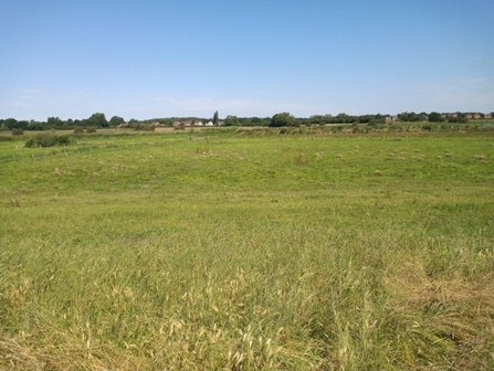
The Humberhead Levels straddles the borders of Yorkshire, Lincolnshire and Nottinghamshire, where rivers draining 20% of England meet at the Humber Estuary. Surrounded by vital transport networks and industrial heartlands, the area also has some vast areas unbroken by road and rail.

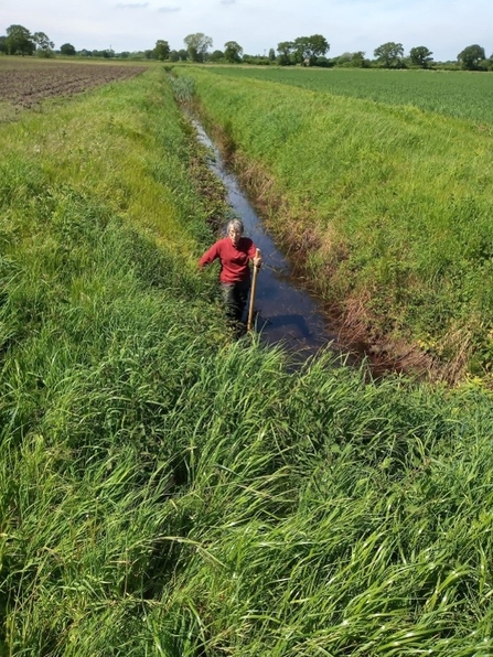
Because the area is very flat and low-lying, it is one of the most productive cropping areas in Britain. The farmland is intensively farmed, generally high input cereals and root crops, in very large, open, geometric fields divided by ditches and dykes, with scattered and fragmented semi-natural habitats.

The Humberhead Levels not only include the internationally-important lowland raised bogs Hatfield and Thorne Moors; they also provide wetland habitats, floodplain grazing marsh, reedbeds and wet pastures. The area is home to a number of important wader species, including snipe, redshank and lapwing, as well as other wildlife like nightjars and rare insects.

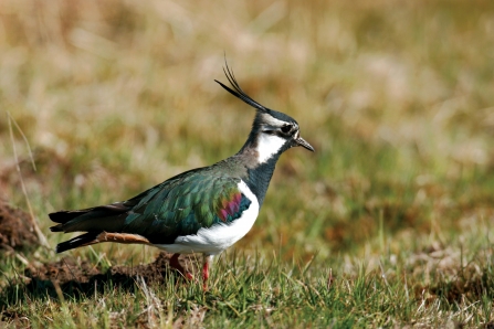
Lapwing credit Carl Watts

90% of the UK’s lowland peat has been drained for agriculture; creating some of the best farming land in the UK, but exposing and destroying vital peatland habitat and releasing CO2. 

What did the project involve?

Supported by the Lowland Agricultural Peat Water Discovery Pilot scheme, which expanded on the findings of The Caudwell Report, The Humberhead Levels LAPWDP project aimed to:

  1. Provide farmers and land managers on areas of lowland peat in the Humberhead Levels with effective water level management interventions to preserve lowland peat.
  2. Give an indication of associated financial opportunities for individual farm businesses and the wider Humberhead Levels area.
  3. Provide a number of case studies to inspire other local action in the area.

7 farms were involved in the project, covering an area of approximately 425ha. These farms provide a representative sample of the types of farms and land use in the region and of other lowland peatlands used for agriculture in England. 

The project was split into two parts; one to develop a design for a water management plan, and another to investigate the potential financial opportunities the project offered for local farmers and landowners. 

The team undertook a number of surveys across the land, including site visits to collect data on peat depth, water levels and ecological data, as well as interviews with landowners and HHL stakeholders. Designs were then developed for areas identified as appropriate for water level management; these were simple sluice structures set at a ‘target water level’ height within internal ditches to maintain a higher water level during dry periods. 

Humberhead levels

The project then worked with design and financial consultants, using Peatland Code and UK Habitat post-intervention plans for Biodiversity Net Gain (BNG), to calculate potential ecosystem services and associated income generation for individual farms and the project as a whole. 

What did the project discover?

Results of the project showed that broadly, Countryside Stewardship payments would currently be the most appropriate options for those areas of land where peatland restoration is possible. 

The project also concluded:

  1. Re-wetting of lowland agricultural peat is complex and requires collaboration between land managers and funders to deliver an achievable solution. The sluices proposed will reduce the rate of peat drying when water levels drop but ongoing monitoring and management will be required to protect the peat.
  2. The green finance market is not reflective of the ecosystem service provided by lowland peat. Higher Tier Countryside Stewardship payments relating to lowland agricultural peat are the most viable option for individual farmers within a wider hydrological network.
  3. Each farm and farmer is different, there is no ‘blanket’ solution and farmers are best placed to lead on the development of land use change plans.
  4. Landscape scale investment is required for effective protection of lowland agricultural peat.
We’re very excited to find that there is potential to manage water levels on lowland agricultural peat to reduce carbon emissions whilst delivering a financially viable income stream and allowing ongoing agricultural use of the land.

Working with farmers to find an achievable solution provides ‘win wins’ for both the long-term resilience of the farm and the environment. There is potential to build on the efficiencies we have gained during this process, expanding delivery to other farms within the Humberhead Levels as well as sharing learning with other organisations delivering similar work nationally.

Managing the agricultural landscape to retain its productivity while improving its contribution to biodiversity provides a significant opportunity for the Humberhead Levels National Character Area.
Mike Jones
Humber head levels

What next for the Humberhead Levels?

A follow on funding application for LAPWDP+ has been submitted to the Environment Agency which would involve:

  1. Finalising the water level management plans, applying for permits and submitting funding applications for 3 farms within this project.
  2. Expanding data gathering and feasibility assessments onto new lowland peat farms within the Humberhead Levels. 

If you are a farmer on lowland agricultural peat and would be interested in having a water level management feasibility assessment undertaken on your farm, please contact Mike Jones (mike.jones@ywt.org.uk)